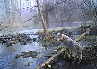
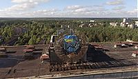
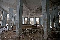
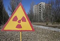
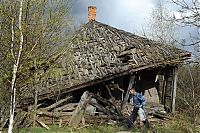
Chernobyl Nuclear Power Plant Exclusion Zone, Pripyat, Ivankiv Raion, Ukraine
Sunday, 17th April 2016, 14:57:30
Album: World & Travel, New uploads: 8, Hits: 1136, Size: 1MiB
A power station (also referred to as a generating station, power plant, or powerhouse) is an industrial facility for the generation of electric power.
At the center of nearly all power stations is a generator, a rotating machine that converts mechanical energy into electrical energy by creating relative motion between a magnetic field and a conductor. The energy source harnessed to turn the generator varies widely...
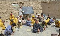
World Travel Landscape Photography
Sunday, 17th April 2016, 14:23:08
Album: World & Travel, New uploads: 15, Hits: 2276, Size: 2MiB
World is a common name for the whole of human civilization, specifically human experience, history, or the human condition in general, worldwide, i.e. anywhere on Earth.
In a philosophical context it may refer to: (1) the whole of the physical Universe, or (2) an ontological world (world disclosure). In a theological context, world usually refers to the material or the profane sphere, as opposed to the celestial, spiritual, transcendent or sacred...


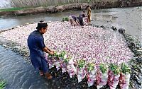
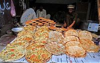
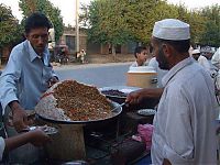
Life In Pakistan
Saturday, 16th April 2016, 07:16:29
Album: World & Travel, New uploads: 19, Hits: 2159, Size: 1MiB
Pakistan (Urdu: پاکِستان), officially the Islamic Republic of Pakistan (Urdu: اسلامی جمہوریہ پاکِستان) (also the Federation of Pakistan), is a country in South Asia. It has a 1,046-kilometre (650 mi) coastline along the Arabian Sea and Gulf of Oman in the south, is bordered by Afghanistan and Iran in the west, and India in the east and China in the far northeast. Tajikistan also lies very close to Pakistan but is separated by the narrow Wakhan Corridor...

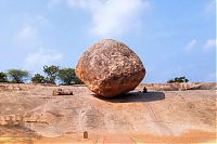
Butterball Of Lord Krishna, Mahabalipuram, Kancheepuram, Tamil Nadu, India
Wednesday, 13th April 2016, 14:55:16
Album: World & Travel, New uploads: 8, Hits: 932, Size: 1MiB
Krishna’s Butterball is a curious tourist attraction in Mahabalipuram, a town about 60 km south of Chennai famous for its stone carvings. The “butterball” is a giant balancing rock, 5 meters in diameter, perched on a smooth slope, seemingly defying all laws of physics.
In Hindu mythology Lord Krishna had an insatiable appetite for butter, and as a child, would often sneak a handful from his mother’s butter jar...


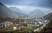
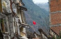
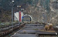
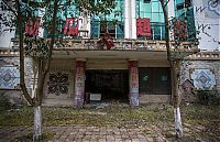
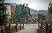
Beichuan Earthquake Museum, Beichuan County, Sichuan, China
Saturday, 2nd April 2016, 23:08:33
Album: World & Travel, New uploads: 38, Hits: 5447, Size: 3MiB
Beichuan Earthquake Museum (北川国家地震遗址博物馆) is a memorial museum of the 2008 Wenchuan earthquake located in Beichuan County, Sichuan, China.
Components
The museum is composed of three parts:
• The museum and service area: The museum and service area is located in the site of the old Beichuan High School. To the south of the museum is the service area.
• Ruins of the old Beichuan county seat: The old Beichuan county seat was located in Qushan Town (曲山镇)...
Protest Against Bull Fighting, Madrid, Spain
Monday, 28th March 2016, 23:44:41
Album: World & Travel, New uploads: 11, Hits: 1302, Size: 1MiB
Bullfighting also known as tauromachy (from Greek ταυρομαχία), is a traditional spectacle of Spain, Portugal,some cities in southern France and in several Latin American countries, in which one or more bulls are ritually killed in a bullring as a public spectacle. The tradition, as it is practiced today, involves professional toreros, who execute various formal moves with banderillas, sharp barbed sticks, in order to subdue the bull itself...


| History | 1 | - | 7 | 8 | 9 | 10 |
|


|
||||||||
