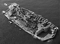
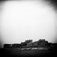
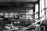
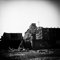
Hashima Island, Nagasaki Prefecture, Japan
Friday, 25th November 2011, 10:00:28
Album: World & Travel, New uploads: 13, Hits: 1355, Size: 1MiB
Hashima Island (端島, or correctly Hashima, as -shima is Japanese for island), commonly called Gunkanjima or Gunkanshima (軍艦島; meaning Battleship Island), is one among 505 uninhabited islands in the Nagasaki Prefecture about 15 kilometers from Nagasaki itself.
The island was populated from 1887 to 1974 as a coal mining facility. The island's most notable features are the abandoned concrete buildings and the sea wall surrounding it...

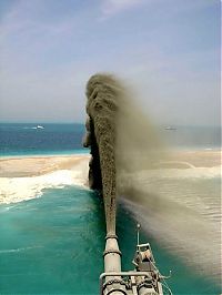
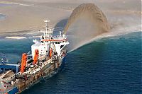
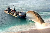
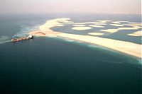
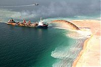
Palm Islands Artificial Archipelago, Dubai, United Arab Emirates
Monday, 1st August 2011, 09:51:22
Album: World & Travel, New uploads: 13, Hits: 2746, Size: 1MiB
The Palm Islands are an artificial archipelago in Dubai, United Arab Emirates on which major commercial and residential infrastructures will be constructed. They are being constructed by Nakheel Properties, a property developer in the United Arab Emirates, who hired Belgian and Dutch dredging and marine contractor Jan De Nul and Van Oord, some of the world's specialists in land reclamation. The islands are the Palm Jumeirah, the Palm Jebel Ali and the Palm Deira...
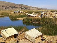
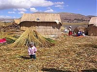
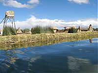
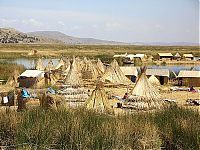
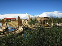
Uros People, Floating Islands Of Lake Titicaca, Peru, Bolivia
Thursday, 16th June 2011, 09:45:45
Album: World & Travel, New uploads: 12, Hits: 2358, Size: 1MiB
Lake Titicaca is a lake located on the border of Peru and Bolivia. It sits 3,811 m (12,500 ft) above sea level, making it the highest commercially navigable lake in the world. By volume of water, it is also the largest lake in South America (Lake Maracaibo has a larger surface area, but it is often disregarded as it is directly connected to the sea).
Overview
The lake is located at the northern end of the endorheic Altiplano basin high in the Andes on the border of Peru and Bolivia...
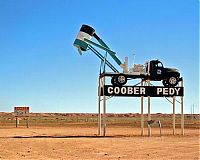
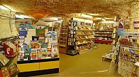
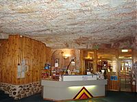
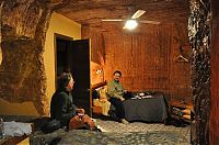
Underground Churches, Coober Pedy, South Australia
Sunday, 5th June 2011, 23:56:42
Album: World & Travel, New uploads: 33, Hits: 8536, Size: 2MiB
Coober Pedy is a town in northern South Australia, 846 kilometres north of Adelaide on the Stuart Highway. At the 2006 census its population was 1,916 (1,084 males, 832 females, including 268 indigenous Australians). The town is known as the opal capital of the world because of the quantity of precious opals that are mined there. It is renowned for below ground residences, mostly in refurbished mines, due to the scorching daytime heat...
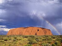
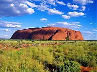
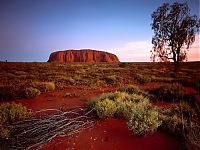
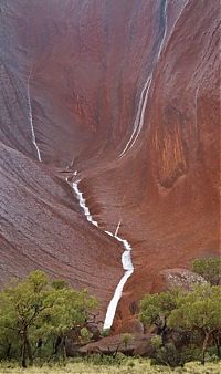
Uluru, Ayers Rock, Australia
Tuesday, 26th April 2011, 13:37:19
Album: World & Travel, New uploads: 18, Hits: 1541, Size: 1MiB
Uluru (/ˌuːluːˈruː/), also known as Ayers Rock, is a large sandstone rock formation in the southern part of the Northern Territory, central Australia. It lies 335 km (208 mi) south west of the nearest large town, Alice Springs; 450 km (280 mi) by road. Kata Tjuta and Uluru are the two major features of the Uluṟu-Kata Tjuṯa National Park. Uluru is sacred to the Aṉangu, the Aboriginal people of the area. It has many springs, waterholes, rock caves and ancient paintings...
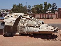
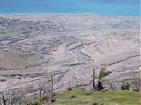
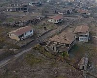
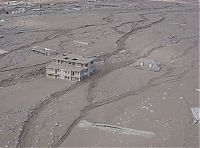
Photos Of Exclusion Zone, Montserrat, Leeward Islands, Caribbean Sea
Thursday, 7th April 2011, 11:14:26
Album: World & Travel, New uploads: 11, Hits: 1395, Size: 1MiB
Montserrat is a British overseas territory located in the Leeward Islands, part of the chain of islands called the Lesser Antilles in the Caribbean Sea. This island measures approximately 16 km (10 miles) long and 11 km (7 miles) wide, giving 40 kilometres (25 mi) of coastline. Christopher Columbus gave Montserrat its name on his second voyage to the New World in 1493, after Montserrat mountain located in Catalonia...
| History | 1 | - | 7 | 8 | 9 | 10 |
|


|
||||||||
