|
|
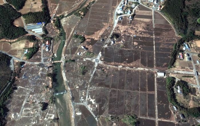
Aerial Photos Before And After 2011 Earthquake And Tsunami, Japan
|
The tsunami warning issued by Japan was the most serious on its warning scale, implying that the wave was expected to be at least 10 m (33 ft) high. The earthquake took place at 14:46 JST around 200 kilometers from the nearest point on Japan's coastline (to the west), and initial estimates indicated the tsunami would have taken 10 to 30 minutes to reach the areas first affected, and then areas further north and south depending on the geography of the coastline. Just over an hour after the earthquake, a tsunami was observed at 15:55 JST flooding Sendai Airport, which is located near the coast of Miyagi Prefecture, with waves sweeping away cars and planes and flooding various buildings as they traveled inland. The impact of the tsunami in and around Sendai Airport was filmed by an NHK News helicopter, showing a number of vehicles on local roads trying to escape the approaching wave and being engulfed by it. A 4-meter (13 ft)-high tsunami hit Iwate Prefecture.
Like the 2004 Indian Ocean earthquake and tsunami and Cyclone Nargis, the damage by surging water, though much more localized, was far more deadly and destructive than the actual quake. There were reports of "whole towns gone" from tsunami-hit areas in Japan, including 9,500 missing in Minamisanriku; Kuji and Ofunato have been "swept away ... leaving no trace that a town was there." Also destroyed was Rikuzentakata, where the tsunami was reportedly three stories high. Other cities reportedly destroyed or heavily damaged by the tsunami include Miyako, Ōtsuchi, and Yamada (all in Iwate Prefecture), Namie, Sōma and Minamisōma (all in Fukushima Prefecture) and Onagawa, Natori, Ishinomaki, and Kesennuma (all in Miyagi Prefecture). The severest effects of the tsunami were felt along a 670-kilometer-long stretch of coastline from Erimo in the north to Oarai in the south, with most of the destruction in that area occurring in the hour following the earthquake.
On 13 March 2011, the Japan Meteorological Agency (JMA) published details of tsunami observations recorded around the coastline of Japan following the earthquake. These observations included tsunami maximum readings of over 3 meters (m) at the following locations and times on 11 March 2011, following the earthquake at 14:46 JST:
|
|