|
|
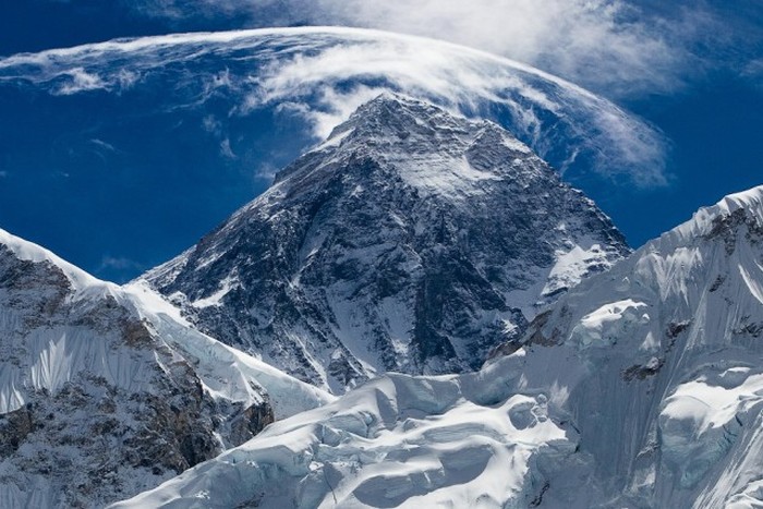
Mount Everest, Mahālangūr Himāl, Himalayas, Sagarmatha, Nepal
|
In 1802, the British began the Great Trigonometric Survey of India to determine the location and names of the world's highest mountains. Starting in southern India, the survey teams moved northward using giant theodolites, each weighing 500 kg (1,100 lb) and requiring 12 men to carry, to measure heights as accurately as possible. They reached the Himalayan foothills by the 1830s, but Nepal was unwilling to allow the British to enter the country because of suspicions of political aggression and possible annexation. Several requests by the surveyors to enter Nepal were turned down.
The British were forced to continue their observations from Terai, a region south of Nepal which is parallel to the Himalayas. Conditions in Terai were difficult because of torrential rains and malaria. Three survey officers died from malaria while two others had to retire due to failing health.
Nonetheless, in 1847, the British continued the Great Trigonometric survey and began detailed observations of the Himalayan peaks from observation stations up to 240 km (150 mi) away. Weather restricted work to the last three months of the year. In November 1847, Andrew Waugh, the British Surveyor General of India made several observations from the Sawajpore station located in the eastern end of the Himalayas. Kangchenjunga was then considered the highest peak in the world, and with interest he noted a peak beyond it, about 230 km (140 mi) away. John Armstrong, one of Waugh's officials, also saw the peak from a location farther west and called it peak "b". Waugh would later write that the observations indicated that peak "b" was higher than Kangchenjunga, but given the great distance of the observations, closer observations were required for verification. The following year, Waugh sent a survey official back to Terai to make closer observations of peak "b", but clouds thwarted all attempts.
In 1849, Waugh dispatched James Nicolson to the area, who made two observations from Jirol, 190 km (120 mi) away. Nicolson then took the largest theodolite and headed east, obtaining over 30 observations from five different locations, with the closest being 174 km (108 mi) from the peak.
|
|