|
|
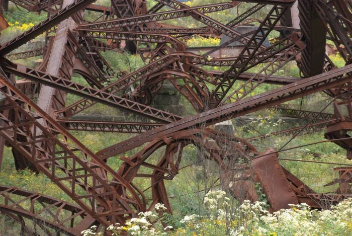
Kinzua Bridge, Mount Jewett, McKean County, Pennsylvania
|
On July 21, 2003, a tornado struck the Kinzua Bridge, snapping and uprooting nearby trees, as well as causing 11 of the 20 bridge towers to collapse. There were no human deaths or injuries. The tornado was produced by a mesoscale convective system (MCS), a complex of strong thunderstorms, that had formed over an area that included eastern Ohio, western Pennsylvania, western New York, and southern Ontario. The MCS traveled east at around 40 miles per hour (64 km/h). As the MCS crossed northwestern Pennsylvania, it formed into a distinctive comma shape. The northern portion of the MCS contained a long-lived mesocyclone, a thunderstorm with a rotating updraft that is often conducive to tornados.
At approximately 15:20 EDT (20:20 UTC), the tornado touched down in Kinzua Bridge State Park, 1 mile (1.6 km) from the Kinzua Bridge. The tornado, classified as F1 on the Fujita scale, passed by the bridge and continued another 2.5 miles (4.0 km) before it lifted. It touched down again 2 miles (3.2 km) from Smethport and traveled another 3 miles (4.8 km) before finally dissipating. It was estimated to have been 1⁄3-mile (0.5 km) wide and it left a path 3.5 miles (5.6 km) long. The same storm also spawned an F3 tornado in nearby Potter County.
Since 2002, the Kinzua Bridge had been closed to all "recreational pedestrian and railroad usage" after it was determined that the structure was at risk to high winds. Engineers had determined that during high winds, the bridge's center of gravity could shift, putting weight onto only one side of the bridge and causing it to fail. An Ohio-based bridge construction and repair company had already started work on restoring the Kinzua Bridge in February 2003. Construction workers had already packed up and were starting to leave for the day when the storm came.
When the tornado touched down, the winds had increased to at least 94 miles per hour (151 km/h) and were coming from the east, perpendicular to the bridge, which ran north–south. An investigation determined that Towers 10 and 11 had collapsed first, in a westerly direction. Meanwhile, Towers 12 through 14 had actually been picked up off of their foundations, moved slightly to the northwest and set back down intact and upright, held together by only the railroad tracks on the bridge. Next towers four through nine collapsed to the west, twisting clockwise, as the tornado started to move northward. As it moved north, inflow winds came in from the south and caused Towers 12, 13, and 14 to finally collapse towards the north, twisting counterclockwise.
|
|