|
|
Hua Shan Hiking Trail, Huayin, Shaanxi Province, China
|
Ascent routes
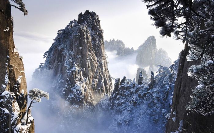
There are two walking trails leading to Huashan's North Peak (1614 m), the lowest of the mountain's five major peaks. The most popular is the traditional route in Hua Shan Yu (Hua Shan Gorge) first developed in the 3rd to 4th century A.D. and with successive expansion, mostly during the Tang Dynasty. It winds for 6 km from Huashan village to the north peak. A new route in Huang Pu Yu (Huang Pu Gorge, named after the hermit Huang Lu Zi who lived in this gorge in 8th century BC) that follows the cable car to the North Peak is actually the ancient trail used prior to the Tang Dynasty, which has since fallen into disrepair. It had only been known to local villagers living nearby at the gorges until 1949, when a group of 7 PLA with a local guide used this route to climb to North Peak and captured over 100 KMT soldiers stationed in North Peak and along the routes in the traditional route. This trail is now known as "The Route Intelligent Take-over of Hua Shan" and was reinforced in early 2000. The Cable Car System stations are built next to the beginning and ends of this trail.
From the North Peak, a series of paths rise up to the Canglong Ling, which is a climb more than 300 meters on top of a mountain ridge. This was the only trail to go to the four other peaks, the West Peak (2038 m), the Center Peak (2042 m), the East Peak (2100 m) and the South Peak (2154.9m), until a new path was built to the east and walk around the ridge in 1998.
Huashan has historically been a place of retreat for hardy hermits, whether Daoist, Buddhist or other; access to the mountain was only deliberately available to the strong-willed, or those who had found "the way". With greater mobility and prosperity, Chinese, particularly students, began to test their mettle and visit in the 1980s. The inherent danger of many of the exposed, narrow pathways with precipitous drops gave the mountain a deserved reputation for danger. As tourism has boomed and the mountain's accessibility vastly improved with the installation of the cable car in the 1990s, visitor numbers surged. Despite the safety measures introduced by cutting deeper pathways and building up stone steps and wider paths, as well as adding railings, fatalities continued to occur. The local government has proceeded to open new tracks and created one-way routes on some more hair-raising parts, such that the mountain can be scaled without significant danger now, barring crowds and icy conditions. Some of the most precipitous tracks have actually been closed off. The former trail that leads to the South Peak from the North Peak is on a cliff face, and it was known as being extremely dangerous; there is now a new and safer stone-built path to reach the South Peak temple, and on to the Peak itself.
|
|